Inverting electromagnetics – a new way to measure groundwater flow
Groundwater that lies beneath tens of thousands of square kilometres of Aotearoa New Zealand represents one of our most precious natural resources. A team of SfTI researchers have developed electromagnetic sensors that, for the first time, could allow water resource managers to accurately measure the volume and flow of groundwater, and consequently the flow of entrained pollutants.
Team
Spearhead Leader, Professor Ian Woodhead – Chief Scientist and Lincoln Agritech Ltd
The project involved additional researchers from the Universities of: Canterbury, Waikato and Otago, the Institute Geological and Nuclear Sciences, and the Victoria University of Wellington.
Snapshot
This technology will help tackle issues of groundwater contamination and the preservation of precious water resources as parts of the world suffer the effects of climate change.
Key to project’s success is improving the sensitivity of the prototype while also dramatically reducing its power requirements.
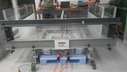
Field trials are using a prototype of the technology with significant improvements achieved in magnet and sensing technology that underpin the sensors.
The SfTI Spearhead team continues to explore collaborations with businesses, particularly with a view to visualising data gathered by the sensors.
The Spearhead team, headed by Lincoln Agritech’s Professor Ian Woodhead and Dr Ian Platt, and featuring experienced scientists from across our universities and GNS Science, have developed a prototype electromagnetic-based sensor that could for the first time allow researchers to peek at groundwater and also determine flow in aquifers.
Understanding our precious groundwater resources
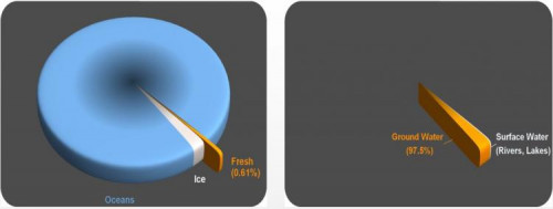
More than 97 percent of the freshwater in the world is groundwater. The water feeds rivers and lakes and is also used for town and city supplies, agriculture and industry. It is mostly derived from rain that travels near the ground surface or deeper in aquifers, fed from water that has seeped through the Earth’s surface over thousands of years, forced by gravity into crevices underground. It can take 50 years between any pollution and the emergence of groundwater for drinking.
Groundwater is vital to our natural environment and as a human resource, so we need tools to efficiently monitor its health, especially in hard to reach aquifers. At present we can only measure groundwater at a point from a well, or between two wells by estimating the aquifer characteristics. Both methods are approximations of the actual groundwater flow rate. More representative measurements, such as provided through this project, will help provide understanding of the source and destination of groundwater and contaminants they may carry.
Underground sensing - how does it work?
The researchers have developed a novel groundwater sensor, based on the age-old Faraday effect (see diagram below) that detects miniscule signals caused by the slow-moving groundwater. This new technique allows the sensor to detect and quantify sources of water, its speed and direction.
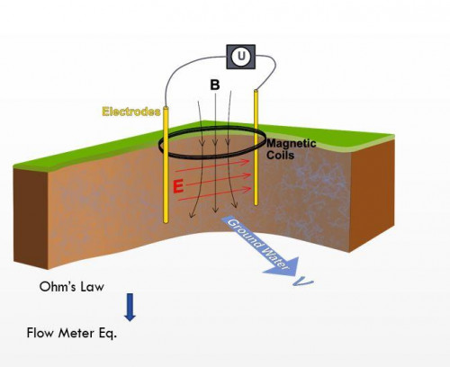
The prototype can be transported on a utility vehicle. It currently measures down to a metre, but with the addition of alternative magnetic coils, this should increase to 10 metres.
The science around the sensor is very challenging. There are no alternatives that avoid small scale variations that can measure the very small speeds that accurately gauge groundwater flow velocity. The sensing technology requires precise manipulation of large-scale magnetic fields and very accurate detection of electromagnetic signals, while compensating for the background electrical noise that might muddy the picture.
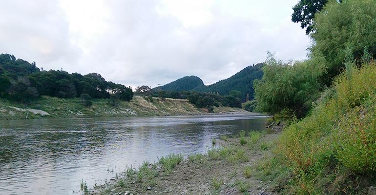
A prototype is currently undergoing field trials at a site on the Selwyn River in Canterbury. Significant reductions in the equipment’s power usage requirements mean that it can now be powered with a regular car battery.
Making sensors cost effective and accessible
The project’s aim is sensor technology that is minimally invasive and can be deployed cheaply. In this way, local authorities could monitor the flow of groundwater to preserve the resource and limit its contamination with pollutants.
The team is also working on ways to visualise the data and merge it with other layers of data so it is of immediate use to water quality managers.
Helping tackle wicked problems
Commercialising the technology has serious potential for governments and water authorities internationally as they struggle to get to grips with how to measure and manage groundwater resources. This will be vital as the world faces the impacts of groundwater contamination, climate change and more frequent droughts.
Project background
This Spearhead Project commenced in 2016, ending in June 2021 and was funded a total of $3.2M. The project was initiated through a process whereby a cross-disciplinary group of academics and practitioners came together to design research projects with the aim of supporting solutions for some of Aotearoa-NZ’s grand challenges.